
Sources for Finding Glendale Neighbors
A public block view is a set of dated clues. The parcel map defines the lots. The assessor identifies titled owners and separates each parcel's situs from the owner's mailing address. City neighborhood data names registered civic areas, while historical directories can show a listed householder in an older edition. Voter information has a narrow legal route and is not an open street-browse tool. Those distinctions keep a search for Glendale neighbors from becoming a claim about every person at an address.
| Block source | Block-level clue | Access route |
|---|---|---|
| Maricopa Parcel Viewer | Adjacent parcel shapes, APNs, subdivisions, ZIP layers, and selected attributes | Free public map with click, shape, and buffer tools |
| County Assessor | Owner, separate mailing and situs addresses, legal description, and deed link | Free address, owner, or APN search |
| Glendale neighborhood GIS | Registered area name, status, HOA and watch flags, districts, and landmarks | Public city ArcGIS service |
| Statutory voter file | Authorized registration fields, with protected people omitted | Written county request under purpose and fee rules |
| Historic reverse directory | Listed householders arranged by address for one edition | Arizona Memory, library, or archive collection |
The table is also a limit chart. An assessor name proves an ownership role, not occupancy. A neighborhood boundary proves that the parcel falls within a civic area, not that every person joins its group. A directory entry reflects one publisher and year. Keep the source and date next to each name rather than merging them into a supposed household roster.
Shape a Glendale Neighbor Block
A block should be drawn from its street segment, cross streets, parcel faces, and physical breaks. ZIP codes are too broad. A simple radius can jump across an arterial, canal, rail line, or another subdivision. Glendale's west-valley grid also has numbered avenues, drives, and lanes that may be separate parallel alignments. Preserve the full direction and suffix when locating the starting address.
The Maricopa County Assessor Parcel Viewer lets a reader select parcels, subdivisions, sections, MapIDs, and ZIP polygons. For nearby lots, a tight polygon along the parcel fronts is often truer to the block than a wide circle. If the question expands to a whole named road, the Glendale by-street directory carries that longer address chain.
Note: A postal “Glendale” label does not establish City of Glendale jurisdiction; confirm the parcel and city-limit layer before contacting a custodian.
Select Glendale Neighbor Parcels
The official viewer supports a precise adjacent-parcel workflow. Enable Parcels under Selectable Layers. Locate the target address, then choose Create new results and set Parcels as the search layer. Point, line, polyline, extent, circle, polygon, and freehand polygon shapes are available. A buffer can expand a drawn shape. Multi-part mode permits several shapes before Search runs, and Add or Remove controls refine the result set.
- Locate the exact Glendale address and click the parcel beneath the map point.
- Draw a small polygon around the lots that face or touch the chosen block segment.
- Open the results or attribute table, then record each APN and physical address.
- Follow each APN into the Assessor search and note the titled owner and distinct mailing address.
- Label every result with its source date and leave occupancy unclaimed unless another lawful record supports it.
The Parcel Viewer selection help pictured below shows the layers and feature-selection approach used to turn one address into a set of nearby lots.
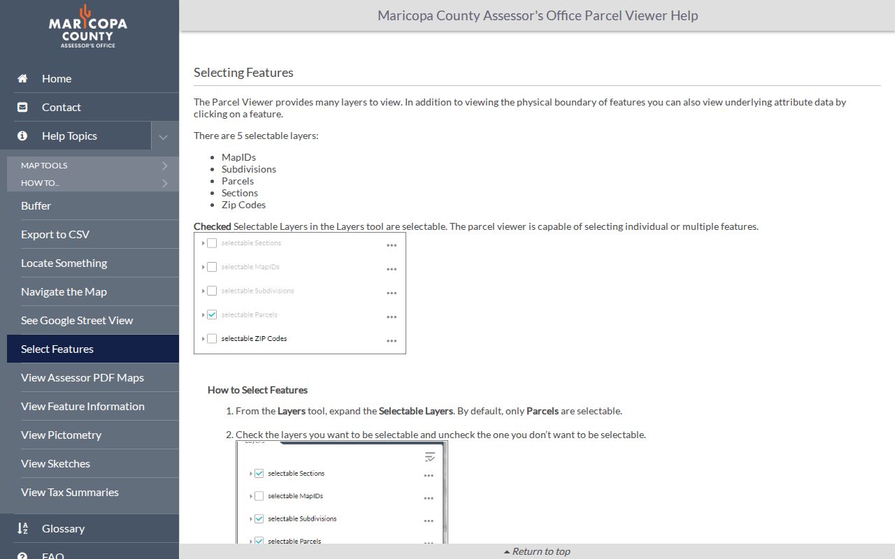
The selection screen supports a parcel-based answer instead of a loose distance guess. That matters near canals, angled roads, and irregular historic parcels.
The viewer's layer and attribute-table help supplies the next screen shown here. Its controls can move layers, change transparency, open a table, and inspect descriptions.
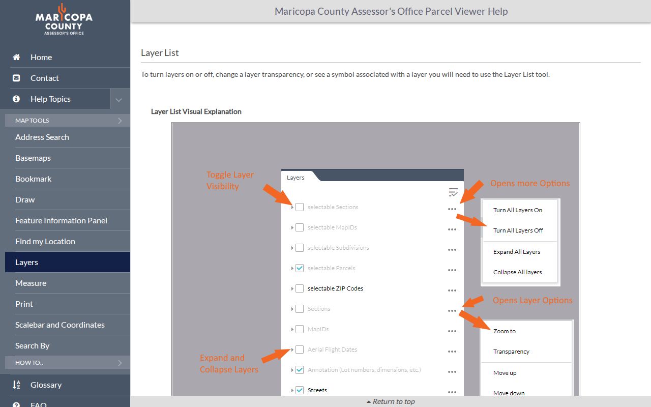
Layer controls help separate parcel boundaries from subdivision, ZIP, section, and other geography. They do not turn the map into a list of occupants.
Open the Assessor detail for each selected APN rather than copying a map label alone. The parcel record can supply the titled owner, physical address, separate mailing address, legal description, subdivision, deed reference, land class, values, and building facts. Selected map features are capped at 1,000, which is ample for a tight block but another reason to avoid an unfocused citywide shape. Trust and company ownership may require a deed search to understand the recorded role. Even then, the result remains a parcel finding. It does not identify every person connected to the place.
Read Glendale Neighborhood Boundaries
Glendale's Community Notification Program reworked the former Registered Neighborhood Program. The city says the older interactive map remains while it develops a broader map. Program benefits include city communication, a liaison, volunteer and tool-sharing support, and HOA Academy. The public contact is neighborhood@glendaleaz.com. These are civic connections, not a directory of private members.
The city's registered-neighborhood GIS layer can expose an area name, boundaries, active status, registration or revision dates, HOA and neighborhood-watch flags, school and council districts, utility district, year constructed, unit counts, vacant lots, parks, churches, and other landmarks. Its data are based on registrations with Neighborhood Partnerships.
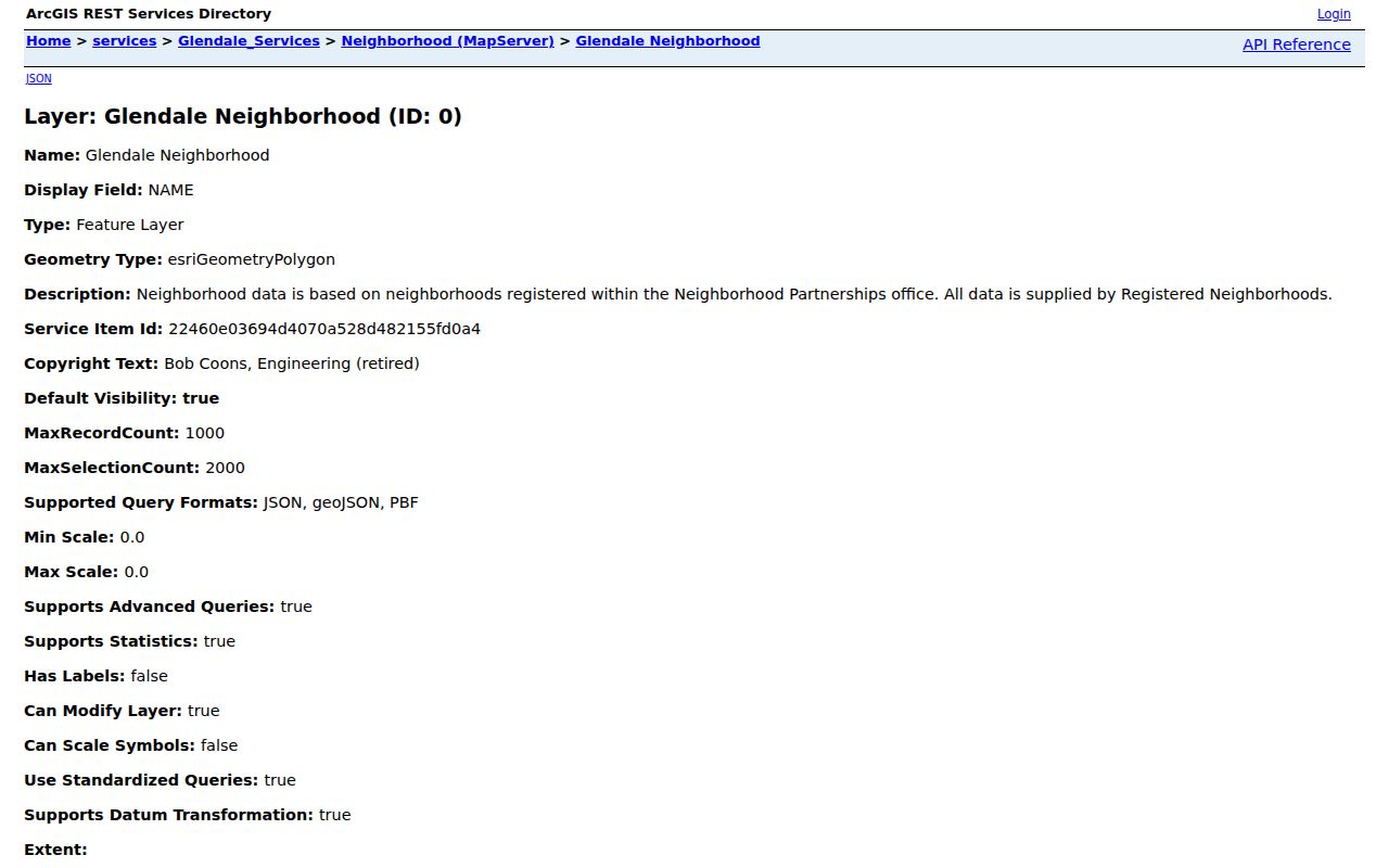
The captured service view shows why the neighborhood layer belongs beside the parcel map. One supplies a civic area and public attributes; the other supplies legal parcel geometry.
Community Notification
City communication and registered-area support. Email neighborhood@glendaleaz.com.
Neighborhood GIS
Public names, boundaries, status, district, HOA, watch, and landmark fields.
Planning Notices
Case-specific owner-radius and registered group contacts for an active land-use matter.
Glendale Voter Data by Block
Arizona's individual voter portal verifies a voter's own record through identifying inputs. It is not a public neighbor search. A public voter file comes from the Maricopa County Recorder through a signed request. State law limits use to political or party activity, a campaign or election, redistricting, or another use specifically authorized by law. Internet posting is barred. The county accepts requests by its online route or downloadable form, and in-person inspection remains a fallback.
The county does not sell an arbitrary street or ZIP slice. Requests are bounded by precinct, legislative, congressional, supervisorial, or countywide geography. An authorized file may then be filtered locally. Protected voter records are omitted. Registration fields can include a name, residence and mailing address, party, registration date and status, districts, birth year, supplied telephone, and participation history. Participation never reveals a ballot choice.
For older register snapshots, Arizona law sends post-election computer-output lists or electronic records to the State Library, Archives and Public Records. That archive route can support block history, but it remains governed by coverage, access rules, and protection. A missing name cannot prove a person was absent from the Glendale block.
Compare Glendale Neighbor Search Sources
Official sources answer narrow questions and identify their keeper. Commercial neighbor tools blend deeds, assessment rolls, directories, and marketing data. That blend may be quick, but it can retain an old association or mistake a titled owner for a current occupant. It should never replace the source record.
| Measure | Official block records | Commercial compilations |
|---|---|---|
| Source clarity | Office, record type, and parcel or case can be identified | Underlying source and update date may be unclear |
| Meaning | Shows a defined role such as owner, registrant, or civic contact | May merge roles into a broad person profile |
| Correction | The named custodian controls its own record | Suppression changes only that publisher's display |
| Best use | Documented civic, family, property, and neighborhood research | Unverified lead requiring confirmation |
Owner mailing address, parcel situs, business address, and claimed residence answer four different questions. Keep them separate. Removing a commercial listing also does not erase the deed, case, or public filing from which a detail came.
Map Glendale Neighbors Through Time
A reverse, or criss-cross, directory orders listed householders by address. It can reveal a block in one publication year, including multi-unit, rear, vacant, or telephone entries when the publisher used them. Glendale may be inside a Phoenix or Salt River Valley volume, so search the scan as well as the title. Glendale Public Library can check local-history, telephone, directory, yearbook, newspaper, obituary, and vertical-file holdings when the digital catalog ends.
Historic Downtown and Catlin Court often support early plat, directory, newspaper, and fire-insurance map work. Mid-century Glendale tends to gain better telephone-book, permit, aerial, and parcel-history coverage. Arrowhead Ranch and newer north Glendale blocks lean more on plats, GIS, neighborhood names, and recent municipal files. Registered neighborhoods, subdivisions, ZIPs, precincts, and council districts are independent layers. A block history should record each one in its own column.
Note: Directory absence may reflect publisher coverage, an unlisted person, rural delivery, or a missing edition rather than a move.
Protect Glendale Neighbor Privacy
Public block records stop well short of a household roster. Parcel and deed systems do not name all occupants or family members. Utility and delivery customer identities are not public neighbor lists. HOA, congregation, club, and block-watch rosters stay private unless the group chooses to publish a contact. Planning's notification list is a special channel for an active land-use case, not a general people directory.
Arizona's Address Confidentiality Program uses a substitute address for eligible survivors. Protected voter procedures can also seal qualifying registration records. Court rules, vital-record eligibility, and motor-vehicle privacy create other firm limits. Public access never authorizes surveillance, threats, deception, or repeated unwanted contact. Arizona stalking and harassment laws turn on conduct and purpose even when the first clue came from a public file.
Lawful use. Research Glendale neighbors for civic awareness, community history, reconnection, or personal safety. Never use block data to watch, intimidate, harass, or harm anyone.