
Trace a Glendale Street Address
A street-by-street search works best as a chain. No single Glendale roll proves who now lives behind a door. The Maricopa County Assessor identifies the tax parcel and titled owner. The Parcel Viewer puts that parcel among the lots around it. Recorder instruments show changes in ownership, while permits and dated directory entries add a building or householder context. Keep the APN, or Assessor Parcel Number, beside every note because it is more stable than an address label.
- Normalize the number, direction, street name, suffix, and unit. Search the Maricopa County Assessor and save the APN, situs address, owner, legal description, and deed reference.
- Open the Assessor Parcel Viewer. Confirm the selected parcel and inspect the adjoining lots instead of trusting a geocoder point alone.
- Use the current owner and deed reference in the Recorded Document Search. Match the legal description before accepting a deed.
- Ask Glendale Development Services for permits or code records by the exact address and APN. A named applicant or contractor shows a project role, not a resident.
- For a lawful historical question, compare dated reverse directories and any voter material that can be released under Arizona law.
This order limits same-name mistakes. It also separates a parcel owner from a listed householder. If the goal changes to one named person rather than an entire street, the Glendale resident lookup uses a different verification path.
Search Glendale Streets Precisely
Glendale addresses sit in the Phoenix metropolitan grid. Numbered avenues, drives, and lanes may run near one another, so the suffix cannot be dropped casually. Directions use E, N, W, S, NE, NW, SE, or SW. Street types work best in forms such as ST, AVE, PL, and LN. The Assessor permits an address without city, state, or ZIP, and its help advises removing the street type when an exact query fails. An APN can be entered with or without punctuation.
| Assessor control | Input | Needed | Glendale search use |
|---|---|---|---|
| Search box | Text with autocomplete | Yes | Accepts APN, owner, address, MCR, personal-property account, or mobile-home details |
| Search suggestions | Result type | No | Choose parcel, owner, address, business property, or mobile home |
| Search | Button | Yes | Runs the selected suggestion or formatted query |
The official Assessor search instructions show the accepted forms. The captured help screen makes those input rules visible:
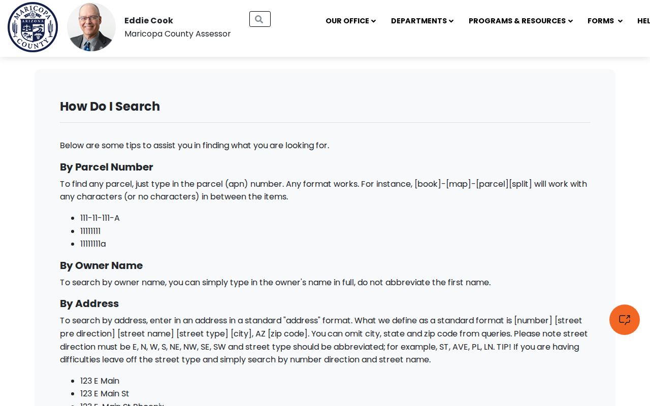
Use the displayed formats to reduce false matches among Glendale's numbered corridors. Record the query that worked so the search can be repeated later.
Note: If an address fails, remove the suffix once, but restore it before deciding which Glendale parcel is the intended property.
Glendale Situs Versus Mailing Address
The parcel card keeps two address concepts apart. The situs address is where the land is physically located. The owner mailing address is where assessment and tax correspondence goes. It may be a post office box, management office, trust contact, or another state. A matching mailing and situs address supports an owner contact trail, but still does not prove that the owner occupies the home.
- Parcel
- A separately identified piece of land used for assessment and mapping.
- Situs address
- The physical property address, distinct from the owner's correspondence address.
- Plat
- A recorded map that lays out lots, blocks, streets, and other land divisions.
- Criss-cross directory
- A directory arranged by street and house number instead of primarily by surname.
A Glendale parcel result can include owner name, both addresses, legal description, subdivision, lot or map, property use, valuation fields, tax-area code, building facts, and a link toward the map or recorded document. Sensitive identifiers and a roster of occupants are not parcel-card fields. When an LLC or trust is shown, keep the entity name exactly as indexed before moving to Recorder records. The public page does not create a parcel-history report; the Assessor accepts a focused request at asr.pa@maricopa.gov when the APN is supplied.
Walk Glendale Blocks in GIS
The Parcel Viewer turns one address into a true street segment. Enable Parcels as a selectable layer, locate the target address, and click the polygon under the geocoder point. A point, line, extent, circle, polygon, or freehand polygon can select more lots. “Create new results” starts a clean set, while add and remove actions refine it. The Feature Information panel and results table then let a researcher cycle through each selected APN.
The official Parcel Viewer geocoder help shows how address and intersection searches are formatted:
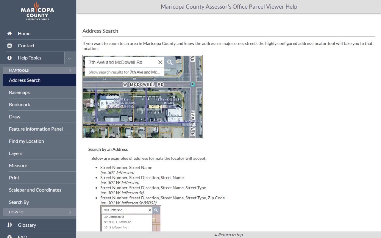
The screenshot is useful before a map session because a point only locates the street. The parcel polygon underneath supplies the land identity. A tight polygon along the parcel fronts is often better than a broad circle, which may cross Grand Avenue, an arterial, a canal, or another block.
Selectable layers also include MapIDs, subdivisions, sections, and ZIP codes. Drawn searches can return up to 1,000 features. Use a small extent for street directory work, then open individual assessor records rather than treating a bulk map row as a complete property file.
Glendale Records Indexed by Address
Address sources overlap, but each has a narrow role. The modern Glendale street directory is therefore a research ledger, not one official resident register. Dates and record roles should travel with every extracted name.
| Address source | Official keeper | Evidence supplied | Access channel |
|---|---|---|---|
| Property assessment | Maricopa County Assessor | Owner, situs, mailing address, APN, legal description, values | Free web search; parcel-history request by APN |
| Parcel geography | Maricopa County Assessor | Lot boundaries, adjoining parcels, subdivision, section, ZIP | Free Parcel Viewer and attribute table |
| Deeds and plats | Maricopa County Recorder | Indexed parties, document sequence, legal description, map references | Free index and unofficial image; office copy or certification |
| Tax account | Maricopa County Treasurer | Parcel-linked tax account and payment context | Online parcel lookup |
| Permits and code files | Glendale Development Services | Work dates, applications, inspections, project roles | Department search or focused public-record request |
| Voter material | Maricopa County Recorder/Elections | Registration data allowed by statute, never ballot choice | Written request, in-person inspection, protected fields withheld |
| Reverse directories | Libraries and Arizona Memory | Dated householder or telephone listing by address | Digital scan, local shelf, microfilm, or staff help |
The Maricopa County Treasurer parcel search supplies the tax-account branch of that chain. Its captured lookup screen shows the parcel-centered route:
The tax page should be matched back to the Assessor APN. A tax account adds fiscal context but does not identify every person at the situs.
Chain Glendale Street Deeds
An address is not the Recorder's most durable search key. Start with the current owner and acquisition deed shown by the Assessor. In the Recorder index, search the owner as a grantee, narrow by document type and date if needed, then compare the image's APN or legal description. Record the document number, date, grantor, grantee, type, and page count. The grantor on the verified deed becomes the next name to search backward.
The Recorder also accepts last and first name, business name, document code, date range, document number, and book, page, or map references where available. Its separate full-text mode can search an address or legal description only across the latest two years, so it is not the long-run deed-chain tool. Result rows normally show indexed parties, recording date, type, pages, and an image link. Unofficial images can be viewed without charge. Official copies cost $1 per page, and certification adds $3 per document. For help, use the Recorder request channel or call 602-506-3535.
Match the land. Never extend a Glendale deed chain on a name alone. Confirm the APN, legal description, or recorded plat reference at every link.
A deed shows an ownership interest. A return address may belong to counsel, escrow, or a mailing destination. Neither fact creates a household roster.
Date Glendale Addresses With Permits
Permit files help explain when a building, addition, conversion, or major system entered the official record. Search or request Glendale Development Services material with both the exact address and APN. Ask for the application, issued permit, inspection log, and certificate or final status, rather than relying on a summary row. If a portal does not expose the file, the Glendale public-record request route is the municipal fallback under Arizona Public Records Law.
An applicant, contractor, architect, or property manager appears because of a project role. That role is not proof of residence. Code and GlendaleOne service records may also be releasable by address, subject to redaction and active-case limits. Describe the location, date span, subject, and department narrowly so staff can find the responsive file.
Read Glendale Streets in Reverse
A reverse or criss-cross volume lists a street in house-number order. That makes it useful after the parcel search, especially for a past publication year. Glendale often appears inside Phoenix and Salt River Valley volumes rather than under a stand-alone title. Later products may mark a phone, ownership status, spouse, or householder, while rural routes, apartments, rear units, and vacant entries need careful reading.
Use Arizona Memory directory scans when available. For gaps, ask Glendale Public Library about local-history shelves, telephone books, yearbooks, newspapers, vertical files, noncirculating items, and current database rules. The full historical shelf belongs in the Glendale city directory collections; street work should extract only the dated address sequence needed for the parcel at hand.
Note: A directory entry shows what a publisher printed for one edition, not a verified statement of continuous Glendale residence.
Resolve Lost Glendale Street Labels
Central Avenue divides the metropolitan avenues and streets, while Washington Street forms the north-south baseline. Most Glendale numbered-address searches therefore depend on the W direction and a complete suffix. Grand Avenue cuts diagonally through the grid and creates irregular intersections and parcel shapes. An old directory label may also predate annexation or reflect a rural route.
No authoritative source in the Glendale research establishes one citywide renumbering year, so none should be assumed. When an address disappears, compare the period directory map, a recorded plat or MCR reference, and the deed's legal description. Canals and rail alignments can explain an old land description that a modern geocoder cannot place. Maricopa County records generally begin after the county's 1871 creation, while municipal records begin with Glendale's 1910 incorporation.
This is a key street directory lesson: “not online” only describes the web result. Older books, microfilm, office terminals, staff indexes, retained originals, and archive finding aids may continue the trail.
Confirm Glendale Street Jurisdiction
A postal line that says Glendale does not prove the parcel lies inside the City of Glendale. Some nearby places fall in Phoenix, Peoria, or unincorporated Maricopa County, and annexation does not force an immediate postal change. Verify the parcel, tax-area information, and city-limit layer before asking for permits, code files, or local court records. USPS answers delivery questions. City and county GIS answer jurisdiction questions.
Keep postal city, municipal city, county, APN, ZIP, subdivision, precinct, registered neighborhood, and council district as separate facts. They serve different systems. This simple jurisdiction ledger prevents a Glendale street search from going to the wrong custodian, especially around western and northern boundary corridors.
Limits of Glendale Street Directory
Assessment and deed data omit renters, children, and other household members. Utility and delivery accounts are not an open street directory. Motor-vehicle addresses remain controlled by privacy law. Voter data is purpose-limited under A.R.S. § 16-168, omits nonvoters and protected voters, and cannot be republished as a casual public list. An individual portal is for a voter checking their own registration, not for browsing a Glendale block.
Fast growth can also create a time mismatch. The 2025 regional update reported 8,840 net residential completions since the 2020 base. A valid new Glendale address may postdate an old directory, map extract, or precinct file. Save the source date and search mode instead of changing a negative result into “no record exists.”
Lawful use. Use Glendale address records only for lawful personal, property, family-history, or civic research. Never use them to stalk, harass, threaten, or harm anyone.
Owner mailing address, parcel situs, business address, and claimed residence answer four different questions. Label each one. That discipline is what turns a street directory search into a defensible record trail.