
Glendale ZIP Directory Coverage
USPS delivery areas associated with Glendale range from the historic core to the city's northern arm. The coverage descriptions below are working geographic guides, not claims that every address inside a postal polygon lies within Glendale city limits. Exact addresses should be checked in the USPS tool and then against city or county parcel geography.
| ZIP | Glendale Area | Delivery Context | Search Note |
|---|---|---|---|
| 85301 | Historic downtown and south-central Glendale near Glendale and Grand avenues | Central delivery with PO-box services | Older core and Catlin Court corridors |
| 85302 | Central Glendale north toward the Olive and Northern corridors | Glendale delivery | Includes older central areas and the Glendale Community College vicinity |
| 85303 | Southwest and west Glendale toward Loop 101 | Glendale delivery | Check city limits along western and southern edges |
| 85304 | North-central Glendale near Peoria and Thunderbird corridors | Glendale delivery | Postal wording does not settle Phoenix or Peoria edge jurisdiction |
| 85305 | Westgate, State Farm Stadium, and the west-central sports district | Glendale delivery | Use a parcel map for fringe addresses |
| 85306 | North-central Glendale near Thunderbird and Bell corridors | Glendale delivery | The boundary interlocks with Phoenix |
| 85307 | Western Glendale and Luke Air Force Base-adjacent areas | Luke and Glendale postal context | Includes military-adjacent and county geography |
| 85308 | North Glendale, Arrowhead Ranch, and Arrowhead Towne Center | Arrowhead-area delivery | Complicated Glendale, Peoria, and Phoenix edges |
| 85310 | Far north Glendale around Happy Valley and north of Loop 101 | North Glendale delivery | Parts of the postal area may be Phoenix or unincorporated county |
| 85311 | No residential neighborhood area | Glendale PO boxes | Not proof of physical residence |
| 85312 | No ordinary residential polygon confirmed | PO-box or organizational context | Verify the exact recipient with USPS |
| 85318 | No residential neighborhood area | Glendale PO boxes | No situs population or block search |
| 85309 | Luke Air Force Base postal identity | Unique institutional ZIP | Outside ordinary Glendale resident-roll treatment unless an address verifies |
The Glendale ZIP code directory therefore includes normal delivery areas, PO-box-only codes, and a unique institutional code. None should be converted into a resident count or city-limit claim without another official layer.
Prove a Glendale ZIP Address
The authoritative mailing check is the USPS ZIP Code Lookup. Use its address route for a specific property rather than assigning a code from a neighborhood name. USPS answers a delivery question. It does not establish ownership, municipal jurisdiction, a school zone, or which police and permit offices serve the land.
The official lookup screen shows the mailing search entry point:
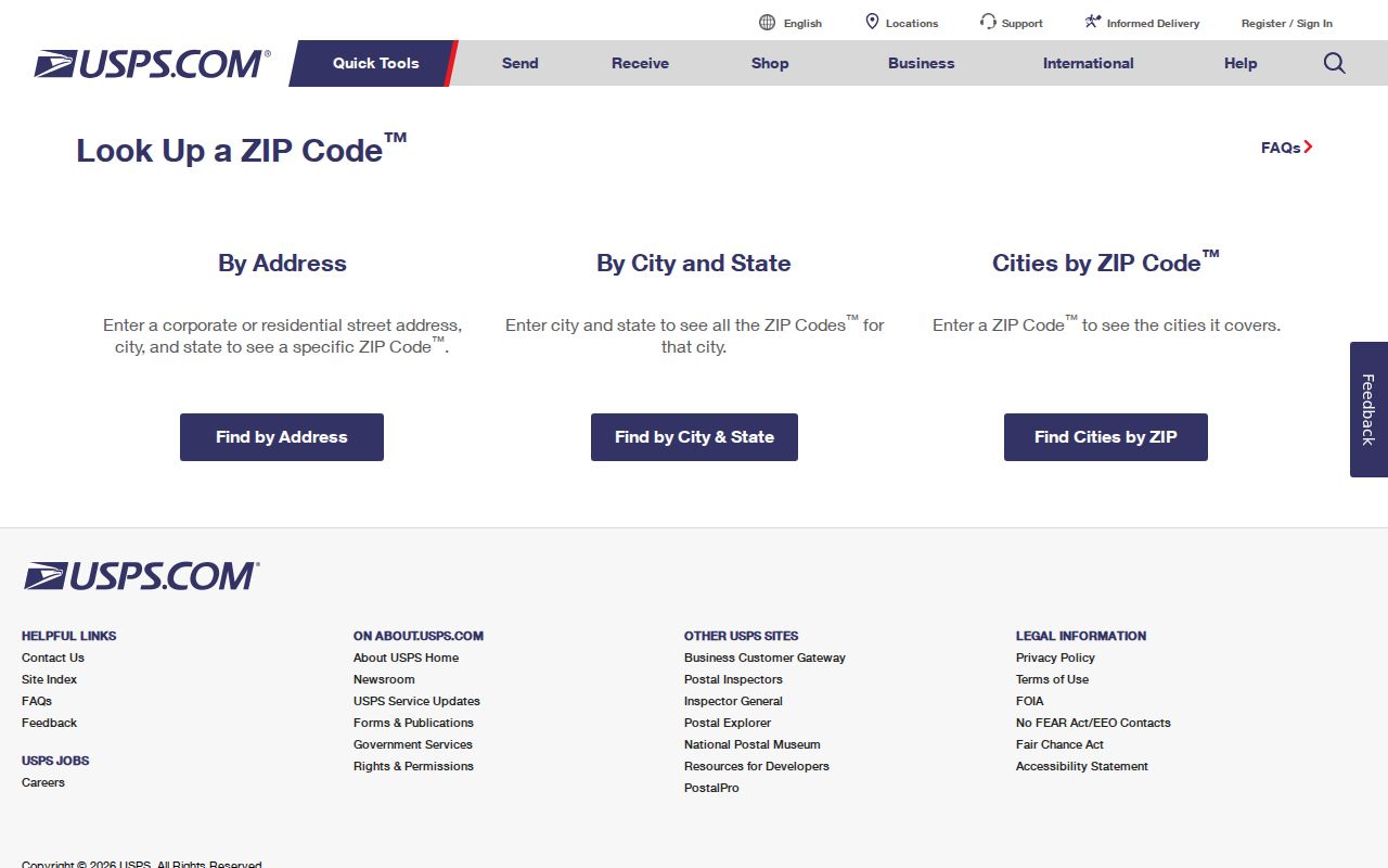
This result should become the postal column in a search ledger, followed by separate columns for municipality, parcel, subdivision, precinct, and registered neighborhood. Glendale uses the Phoenix metropolitan address grid. Central Avenue divides numbered avenues to the west from streets to the east, and Washington Street is the north-south baseline. Most Glendale addresses use W with a numbered avenue, drive, or lane. The suffix matters. Grand Avenue also cuts diagonally across the grid, producing irregular intersections and parcels that make shorthand searches risky.
Note: Keep the full directional and street type when verifying a Glendale ZIP code, because nearby numbered roads can otherwise look alike.
Search a Glendale ZIP Area
A ZIP-wide resident search is really a sequence of narrower official checks. The Maricopa County Assessor's public form accepts a ZIP as part of a full street address, but it does not advertise a stand-alone list of every parcel or resident in one ZIP. The Parcel Viewer is the stronger official tool for selecting a postal polygon and then examining parcel geography inside it.
- Verify the exact mailing ZIP through USPS. Save the normalized address rather than a neighborhood-based guess.
- Open the Maricopa County Parcel Viewer, turn on the Zip Codes selectable layer, and select the correct polygon.
- Draw a point, line, circle, polygon, or extent within the selected area. Record the parcel APNs and physical situs addresses returned.
- Open individual Assessor records by APN or address. Treat owner and owner mailing fields as property evidence, not a list of occupants.
- When the search narrows to one road, continue with the Glendale street directory instead of treating the whole ZIP as one neighborhood.
Voter data does not supply a casual ZIP-directory shortcut. Arizona's self-service voter check is for an individual. A regulated public voter file must be requested for a purpose authorized by A.R.S. § 16-168 and bounded by an allowed district, not ordered as an unrestricted Glendale ZIP list. A permitted requester may later filter the authorized file's ZIP field, but protected voters remain absent.
Glendale ZIP Search Controls
The Parcel Viewer search help documents the controls behind a Glendale ZIP code directory search. Selectable layers include Zip Codes, Parcels, Subdivisions, Sections, and MapIDs. Turning on the right layer matters because a click returns attributes for that active geography, not every map object beneath the pointer.
| Viewer Control | Type | Use in a ZIP Search |
|---|---|---|
| Zip Codes | Selectable layer | Click a ZIP polygon and load its attributes |
| Point, line, or polyline | Graphic selection | Pick parcels along a narrow route or street segment |
| Extent, circle, polygon, or freehand polygon | Area selection | Define a smaller search area inside the ZIP |
| Create, add, or remove | Result action | Build and refine the current parcel set |
| Buffer Graphic | Distance control | Expand the selected shape by a stated distance |
| Feature Information | Results panel | Read attributes for selected features before opening parcel details |
The help page is captured here with its ZIP and buffer mechanics:
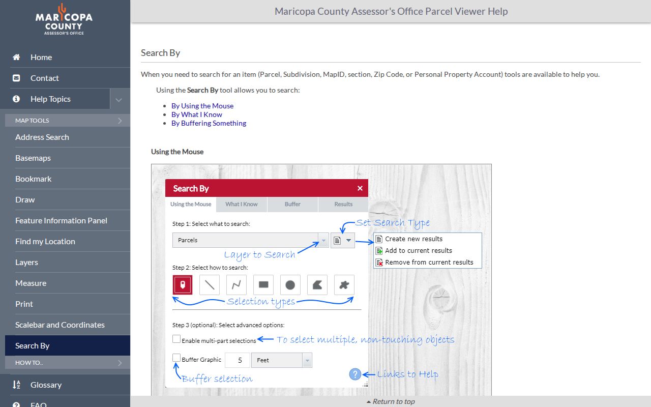
These controls narrow the map to parcel evidence. The viewer caps a selection at 1,000 features, so large Glendale ZIP areas should be split into smaller shapes.
Glendale ZIP Versus City Limits
The central geography trap is simple: a mailing address that says Glendale can be in Phoenix, Peoria, or unincorporated Maricopa County. The reverse can also occur after annexation because a municipal boundary change does not force an instant postal change. This mismatch decides whether a permit, code, police, court, or city-record request belongs with Glendale or another custodian.
The Glendale GIS service directory publishes city limits, address, street annotation, parcel, council district, zoning, and utility-provider layers. For a new or disputed address, Glendale Development Services and GIS handle property inside city jurisdiction; Maricopa County handles unincorporated parcels.
The city GIS catalog exposes the authoritative layers used to test a postal result:
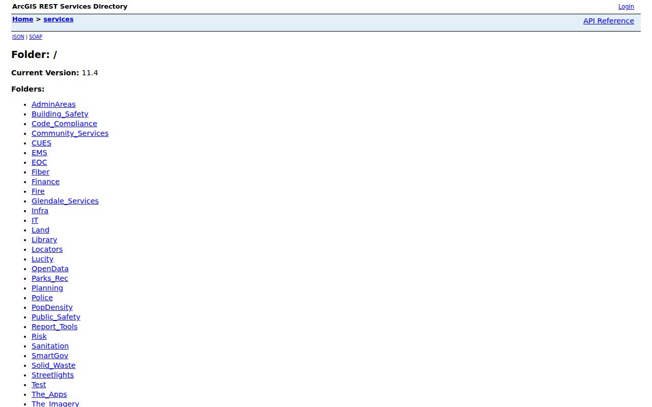
The layer list confirms why one ZIP label cannot substitute for a municipal boundary, parcel, council district, or service-provider check.
Boundary check. Use USPS for delivery, Glendale GIS for city jurisdiction, and the Maricopa County Assessor for parcel identity.
Glendale ZIP Codes Across Eras
One postal area can contain records from very different development periods. Historic Downtown and Catlin Court favor early plats, city directories, maps, newspapers, and long deed chains. Central mid-century districts are often better represented by telephone directories, permits, aerial images, and assessor records. Arrowhead Ranch and north Glendale lean more heavily on subdivision plats, parcel GIS, newer permit files, and association names.
The Westgate and State Farm Stadium area adds commercial entity, planning, liquor-license, and property records. Those sources identify a public role or premises, not a household. Luke Air Force Base shapes western Glendale geography, yet military personnel data is not a public resident directory. ZIP research near the base should remain an address and jurisdiction task unless an official public source supports a narrower conclusion.
These development layers explain why a single method fails across the Glendale ZIP code directory. A reverse directory may work well for an older central address but not for a newly completed subdivision. Parcel GIS and plats can be far more current in the northern growth areas.
New Glendale ZIP Addresses
Glendale's address universe is changing quickly. The Maricopa Association of Governments estimated 265,599 residents and 100,755 residential units as of July 1, 2025. Its update reported 8,840 net residential completions since the 2020 base. A new street, parcel, or unit can therefore exist after an older directory, map edition, data extract, or precinct report was produced.
A missing result should trigger a date check. Compare the Assessor's current parcel data, the city's NG911 address service, development or permit records, and USPS delivery validation. Ask the relevant office when its displayed dataset was refreshed. Do not infer that the address is invalid merely because an older reverse directory or exported list omits it.
For records unavailable online, use the City of Glendale public-record request channel for municipal address and planning files, or contact the county custodian for parcel material. In-person inspection and a focused written request remain valid fallbacks. Historical address research may require a library directory, period map, plat, or archive copy.
Note: A Glendale ZIP code directory result and a parcel record can be current on different dates, so record both search dates.
Glendale ZIP Layers Defined
The Glendale ZIP polygon service is a map layer, not a complete list of people. It supports feature queries, statistics, and pagination, with a 2,000-record service maximum. It is useful for comparing postal polygons with other city layers, but a map response still needs an address or parcel check.
The captured service page shows the official ZIP polygon endpoint:
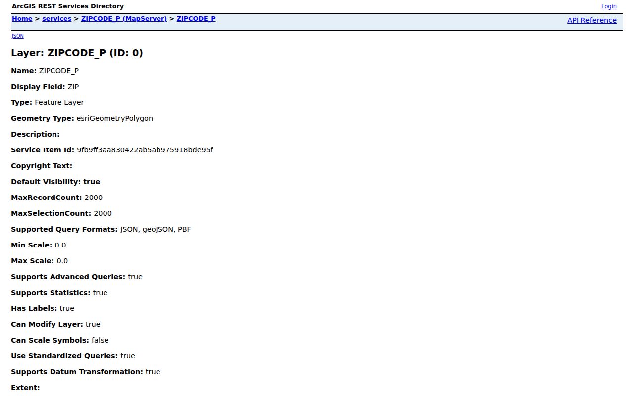
This service supplies geometry for the Glendale ZIP code directory, while USPS remains the source for delivery verification.
- ZIP and ZIP+4
- A ZIP is the broad delivery code. ZIP+4 further narrows mail sorting for an address or delivery group.
- PO-box ZIP
- A postal code used for boxes rather than a normal residential land area. It should not be mapped as a neighborhood.
- Unique ZIP
- A code assigned to a major institution or delivery operation, such as the Luke Air Force Base postal identity in this research.
- Carrier route
- A mail-delivery route within postal geography. It is not the same as a precinct, subdivision, or city council district.
- Situs address
- The physical property address used by parcel and permit systems, distinct from an owner's mailing address.
ZIPs, Census ZIP Code Tabulation Areas, voting precincts, subdivisions, registered neighborhoods, school districts, and council districts all serve different aims and change on different schedules. Keep each in its own column. That small habit prevents a postal label from becoming an unsupported claim about residence or government jurisdiction.